Welcome to TheOhioOutdoors
Wanting to join the rest of our members? Login or sign up today!
Login / Join

Where to set up...

Mao

Member
1,695
109
Coshocton, OH
Dunlap's.jpg

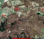
Ok. Ive been getting my butt kicked hunting this strip mine location. I am the only person with permission to hunt this property and it is heavily pressured all around me. Two years ago, I saw a couple nice bucks during the prime time in the climber spot to the far east. I hunted the climber spot on the west side above the bedding area and saw some deer and a nice buck in the early season two years ago. Last year, I didnt see squat their at all. I was wondering how you would set up if you were hunting this property. The brighter blue is a small pond with a creek running into it from the thick bedding area. The wooded areas are largely scrub brush with some oaks here and there. The path that looks like a path running through the middle to the southern tip of the property is a 4 wheeler path that runs by a creek. The farthest location south is a water fall. I would appreciate any help. Thanks!
 

Tree Monkey

Member
1,825
0
NW ohio
That is a tough set up.......I would say set up north east of the bottom of the pond and and south east side mid way up of the bottom finger.....I would keep hunting the east climber set up too
 

Jackalope

Dignitary Member
Staff member
39,145
274
Mao. Just did ya a favor buddy.. Be careful when posting maps of hunting spots. Make sure you remove or paint over the GPS coordinates, road names, or any other identifiable markings.. Trust me, many a good spots have been sniped from good people after they forgot to remove the markings. Tons of people want to hunt Ohio and anyone can see this online for many years to come.. ;) I fixed it for ya..
 

Buckmaster

Senior Member
14,525
205
Portage
Looking at the map. I'd start out in the area in between your "K" and "B".
Looks like a nice draw leading into a thicket.
 

Mao

Member
1,695
109
Coshocton, OH
Mao. Just did ya a favor buddy.. Be careful when posting maps of hunting spots. Make sure you remove or paint over the GPS coordinates, road names, or any other identifiable markings.. Trust me, many a good spots have been sniped from good people after they forgot to remove the markings. Tons of people want to hunt Ohio and anyone can see this online for many years to come.. ;) I fixed it for ya..

thanks a lot man! opps...
 

Fluteman

Senior Member
Supporting Member
7,096
160
Southeast Ohio
I got the gps coordinates earlier. I will let you know where the good bucks were after I come up and kill them all. :D I will have to look argue map later, I can't pull it up right now. Any good fishing up there?
 

dante322

*Supporting Member*
5,506
157
Crawford county
no expert here but I'll chime in any way...

Looks like this was a spring or fall pic, no leaves on the trees. so the bright green areas are evergreens?
I've seen that deer kinda like the shelter and softer ground of evergreen thickets. and the area right through the middle of the property on the west side (assuming north is at the top, if not then the left side) looks like a saddle leading into the evergreens. I'd be tempted to set up in that area,right about where your red marker furthest to the left is, and see what happens.
 
Last edited:

Mao

Member
1,695
109
Coshocton, OH
I got the gps coordinates earlier. I will let you know where the good bucks were after I come up and kill them all. :D I will have to look argue map later, I can't pull it up right now. Any good fishing up there?

thats cool with me... just save me one. haha.. not much of a fisherman. when i do, i go shovelheadin ..
 

Mao

Member
1,695
109
Coshocton, OH
What are the primary food sources in the area? Is that a holler that runs E/W through the middle of the property?

as far as primary food.. i really am not sure. if you start at the main road where the little camera symbols are at the northern part of the map. there is a corn field diagonally northwest across the road. we have seen big bucks in the field and cutting across the road into that field. they use that strip of woods running down to the road... elsewhere, its big woods and i dont know where there feeding. its strip mines so not a lot of good food. have seen more red oaks dropping back in there than usual. my mom almost hit a big one crossing the road on her way to work at the most northeastern part of the map.

there is a bench running east to west across the middle of the property. it runs from about where i have my most eastern climber spot straight across until it meets the 4 wheeler path. it is slightly sloped down to a creek then slants back up the other way to the end of the property. west of the 4 wheeler path begins the thick stuff..
 
Last edited:

formerbowhunter1023

Now Posts as Jesse..
0
0
SE Ohio
I'd focus on the oaks, the shelf, and whatever terrain you can hunt that will funnel movement to/from that corn. I'd be looking hard to find a way to get between bed and food (corn). I'd also try to find some sort of staging area maybe 100-200 yards off the road where they'll hang up prior to crossing the road. I love hunting benches too, so I'd try to find a location that offers and N/S intersection with that bench as far as deer traffic is concerned. I like dante's idea on the evergreens too once the weather turns for the worse...