
You are using an out of date browser. It may not display this or other websites correctly.
You should upgrade or use an alternative browser.
You should upgrade or use an alternative browser.
Random weather thread
- Thread starter giles
- Start date

- 39,958
- 289
From a seasonedhurricane watcher, been in the cone for 13 in 23 years, got smoothed by Ivan, Dennis, Katerina and Sandy.
I can not remember ever seeing a Hurricane make landfall in Canada...
View attachment 161994
Strange for sure. As soon as this bastard floated off into the north Atlantic where storms go to die it rolled a Split-S and is headed back.
 .
.It'll still die as it's going to get decimated by Fionas atmospheric disturbance.
- 39,958
- 289
@Stressless I'm sure you're keeping an eye on Ian like everyone else down here. Really early and the models are bouncing around a lot, should know more late Monday / Tuesday.

Stressless
Well-Known Member
Oh ya, Investi 11 turned into TS Ian - got a thumb on that one - and thanks for the overwatch.. can never be TOO careful.
Around here - started plotting with a grease marker, then dry erase marker on a free power utility map many many moons ago - LoL before internet! ....
Around here .. Now I can just pop up this guys great site and his crawlers bring it all in. http://www.bearpawsweather.com/tropical/index.html
Also NW Fl and specifically my County and even more specifically my zip code is the fastest growing area / per capitol in FL. So many newbies that have no clue and are glued to SM and TWC and others that make drama out of possibilities. Our local FB groups have been blowing up with all kinds memes for smiles for the locals.
Bread and Milk and Gas and water are already being horded. I have a whole home genrac genset with 200 gals of propane that run my well so I just wait for the Weekend Warriors to arrive and que up for MRE's for hunting season. (But I actually do take it very seriously)
When Eglin AFB and Hurlburt AFB (about 20 miles and 10 miles from me) flush their birds - it's time to make ready to defend yourself.


After so many ...


....and just for you Joe...

Around here - started plotting with a grease marker, then dry erase marker on a free power utility map many many moons ago - LoL before internet! ....
Around here .. Now I can just pop up this guys great site and his crawlers bring it all in. http://www.bearpawsweather.com/tropical/index.html
Also NW Fl and specifically my County and even more specifically my zip code is the fastest growing area / per capitol in FL. So many newbies that have no clue and are glued to SM and TWC and others that make drama out of possibilities. Our local FB groups have been blowing up with all kinds memes for smiles for the locals.
Bread and Milk and Gas and water are already being horded. I have a whole home genrac genset with 200 gals of propane that run my well so I just wait for the Weekend Warriors to arrive and que up for MRE's for hunting season. (But I actually do take it very seriously)
When Eglin AFB and Hurlburt AFB (about 20 miles and 10 miles from me) flush their birds - it's time to make ready to defend yourself.
After so many ...
....and just for you Joe...
Attachments
Stressless
Well-Known Member
On a serious note, because I have stayed and dealt with the aftermath of these critters... I have a very healthy respect for the storms and am all prepped.
I took these as part of the County's Community Emergency Response Team (CERT) that went out after Ivan.... 13.5' storm surge which isn't that big as there's not much to pile the water up like at Biloxi with Katernia. 21' surge.


Where ever it hits, if a major storm, it'll be a mess for that community and it's people.
I took these as part of the County's Community Emergency Response Team (CERT) that went out after Ivan.... 13.5' storm surge which isn't that big as there's not much to pile the water up like at Biloxi with Katernia. 21' surge.
Where ever it hits, if a major storm, it'll be a mess for that community and it's people.
Sgt Fury
Sgt. Spellchecker
- 39,958
- 289
@Stressless I wonder why they started calling this a "post tropical cyclone" right before landfall in Canada instead of a "Category 2 hurricane" All hurricanes are tropical cyclones. In the Atlantic they're hurricanes, in the pacific they're typhoons. But I wonder why they stopped calling it a hurricane right before landfall. Sounds like some insurance fuckery was going on.

This kind of explains why.
Gonna be some big deer hit the dirt this week. Tue/W evenings look incredible.
- 39,958
- 289
This kind of explains why.
Not really, or at least I didn't see it. They touched on my question but ain't offer an explanation why they changed what they refer to it as. "Fiona is now a post-tropical cyclone but is still packing hurricane-strength winds.". It made landfall as a category 2 hurricane and is still a category 1 hurricane. But for some strange reason, they stopped calling it a "hurricane" and referred to it as a "post-tropical cyclone".
Wiki says post-tropical cyclone is a former tropical cyclone that no longer possesses enough tropical qualities to be considered a tropical cyclone.[1] The word may refer to a former tropical cyclone undergoing extratropical transition or a tropical cyclone degenerating into a remnant low. A tropical cyclone degenerating into a trough or wave lacks a cyclonic circulation and is referred as remnants instead of a post-tropical cyclone. However, post-tropical cyclones or remnants can continue producing high winds and heavy rains
Meaning it would have to deteriorate below a hurricane to accurately call it a post-tropical cyclone. Somethins fucky
Chancegriffis
Active Member
Joe there are quite a few different reasons to why they would be calling it a ptc or an etc. all of which though, I don’t care to explain at this time lol maybe after a few more cold ones lol
Maybe because it isn't tropical anymore? Tropical Canadian?
Nah. Gonna be some hunters educating deer thoughGonna be some big deer hit the dirt this week. Tue/W evenings look incredible.
Stressless
Well-Known Member
As someone that has fought insurance companies after a lightening strike and home fire in 2004 and Ivan later in 2004 I'm siding w Joe and the Insurance/Insured clauses in the Canadian Government and private sector are gonna get one over on citizens. Even if its 20% of the actual claims, Ivan had 14B$ they just keep going up...
TinyTucky
Active Member

Stressless
Well-Known Member
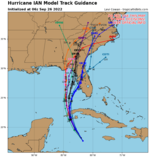
The East side is always the worst side of these critters. The models tightened up overnight and as a major cyclone making landfall, the worst is glancing the peninsula along it's most likely path while still a majority of the storm is over warm water keeping the convection strong.
Gonna be a strong pucker factor for folks from Apalachicola to Tampa for the next 24 hours and then we'll all know who gets it. Highways will start to clog up tonight and be untenable by tomorrow afternoon.

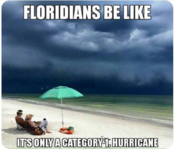
LoL @Sgt Fury used my goto meme

It's not even quite a hurricane yet... when i gets to the other side of Cuba, no land mass and that very warm water it's gonna blow up.

Gonna be a strong pucker factor for folks from Apalachicola to Tampa for the next 24 hours and then we'll all know who gets it. Highways will start to clog up tonight and be untenable by tomorrow afternoon.
LoL @Sgt Fury used my goto meme
It's not even quite a hurricane yet... when i gets to the other side of Cuba, no land mass and that very warm water it's gonna blow up.
Attachments
Last edited:
- 39,958
- 289
Coin flip on this one. State and local is going to err on the side of caution and issue evacuation notices. It'll reach cat 4 but is supposed to rapidly deteriorate to a cat 2 or 1 before hurricane force winds reach land. It's going to get some deterroration from this front thats moving down. The problem is they can't guarantee that will happen, and they won't know for sure until about 16 hours before. It should show signs of deteroration by 3pm Wednesday but it's due to brush Sait Pete area around 7 am that night Not enough time to issue evacuations then so they can't go on speculation.
Clay Showalter
Southern member northern landowner
Being that Tampa Bay is very flood prone, has not seen a major Hurricane in 100 years, the explosion of population, yea this hurricane is going to be a big flooding mess.
Stressless
Well-Known Member
Clay +1, when stationed at MacDill AFB (on the dick tip dangling in Tampa Bay) that was one of our exercises. To clear the base with our equipment in 72 hours as +6" above MSL would flood our deployment storage bays.
Current estimates are 5-10' surge .

Current estimates are 5-10' surge .
Last edited: